Peoples Natural Gas is the largest natural gas distribution company in Pennsylvania and serves about 740,000 customers in southwestern Pennsylvania, Kentucky, and West Virginia. The utility was recently purchased by Aqua Pennsylvania Inc. and is part of Essential Utilities Group.
In 2015, Peoples was using Esri’s Mobile API for an offline application. Two years later, the utility decided to upgrade the application to Esri’s Runtime API. Peoples worked closely with Esri and RamTech, who helped develop the Runtime-based application, to create an offline mobile solution in a versioned environment. As the newly developed solution entered the workflow of Peoples’ field service users, they started running into problems.
Over 800 users were syncing into the application and while Peoples was trying to reconcile and post data from so many different users at once, their ArcGIS servers and virtual machine (VM) started crashing more frequently. With their systems experiencing notable downtime, Peoples was stuck spending hours of valuable time per week trying to fix the crashing issues. They realized they needed to implement changes that would make their mobile solution viable.
Peoples’ answer to the crashing issues was to come up with a new two-database model with bidirectional synchronization capabilities. The first database was to be a versioned databased, housing master GIS data for all of Peoples’ in-house ArcMap users. The other database would be for archived data from Peoples’ mobile workforce and web applications, and would tie into its compliance system. While planning the two-database model, Peoples knew they would need some way to transfer data between the two databases and keep them as synchronized as possible.
After a few attempts to try and develop a synchronization system on their own, Peoples wasn’t able to come up with a solution that worked. While exploring other options, the utility was introduced to the Geonexus Integration Platform (GIP), a commercial-off-the-shelf (COTS) integration solution that offered the bidirectional synchronization capability that Peoples was looking for.
– Scott Ewart, GIS Lead – Peoples Natural Gas
Using GIP, Peoples was able to quickly and easily set up their GIS-GIS integration, synchronizing their archived and versioned databases. They were able to start syncing data in less than 3 days, and their configuration allowed recently collected field data to be automatically uploaded to the versioned database, then edits made to that data would be reflected in the archived database. Nightly synchronization ensured field users started every morning with updated data.
In 2018, Peoples began another project where GIP would end up playing a critical role: the collection and reporting of Tracking and Traceability (T&T) data to satisfy new compliance requirements for gas utilities in the United States. Previously, this data (including DIMP information, measurements, map sketches, etc) was collected manually and ported into CAD by hand. Expectedly, this led to a lack of accuracy in the data and long turnaround times between collection and GIS review.
To solve this problem, Peoples again tried a variety of solutions. They performed proof-of-concepts using in-house and third-party tools including ArcGIS Collector, and eventually decided to utilize their own ArcGIS Runtime Application built in-house. The proof-of-concept proved that Peoples’ primary requirements for the project were met by this application, and Peoples was confident in their ability to customize it to fit their workflow.
– Scott Ewart, GIS Lead – Peoples Natural Gas
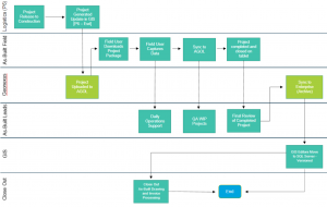
Today, GIP is the main way Peoples migrates data from ArcGIS Online (AGOL) to their staging database in ArcGIS Enterprise. GIP takes projects that are generated by Peoples’ in-house application and uploads them to AGOL, which then helps inform field users that projects are ready for them to work on. Users can download projects, capture data, synchronize it to AGOL, and mark projects as completed right from their mobile iOS devices. GIP then uploads completed projects to the archived staging database for additional use by GIS and closeout teams. This diagram shows the whole process:

Overall, Peoples is seeing major benefits in the two projects involving GIP. The constant server and VM crashes have been eliminated and Peoples can now collect compliance data and accurately report it for the first time. GIP has also greatly simplified the process of moving data between AGOL and Peoples’ staging archived database, allowing fast and easy synchronization of data that helps field users do their jobs every day.
Since implementing GIP, Peoples has completed nearly 2800 projects involving company service pipes, mainline pipes, customer service pipes, and over 138,000 other devices. They also installed four company-owned base stations that help collect highly accurate T&T data; these base stations are capable of tracking assets with an error margin of 6” or less and enable equipment traceability through barcode scanning.
Lastly, Peoples has seen massive improvements in turnaround time across the board. Closeout review turnaround times (days from tie-in submitted to GIS) have dropped from 28 days to 18 days. Even more impressively, GIS review turnaround times (days mapped from tie-in) have dropped from 69 days to just 25 days.
After finding such great success with GIP, Peoples is now looking for more ways to use the program in other areas of their business. In the future, they’re considering integrating SAP with Esri’s Utility Network and making use of integrated SAP and UN data. Like us, it’s clear they believe that integrated systems are the future of data management in the utility industry and have seen how integration can vastly improve workflows across teams.
– Scott Ewart, GIS Lead – Peoples Natural Gas
Geonexus’ platform was built with business logic in mind and allows utilities to connect systems like ArcGIS, Maximo, SAP, and more. The Geonexus Integration Platform opens the door to new possibilities for data integration and asset management, so schedule a demo today and learn how Geonexus can help make the most of your data.