In March of 2015, the City of Detroit watched in horror as yet another house went up in flames. Firefighters arrived on scene where they expected to find a fully functioning fire hydrant, or at least that’s what their records indicated. Instead they found an out of service, frozen hydrant and to make things worse, this wasn’t the first time. Unable to extinguish the fire, due to the neglected infrastructure, the house was destroyed.
In an effort to prevent further disaster, Detroit Mayor, Mike Duggan, tasked the City’s Water and Sewerage Department (DWSD) and Fire Department with establishing an enduring solution for the faulty hydrant issue. Upon review, DWSD found that the hydrant inspection process was being neglected and the City’s outdated, inefficient, paper-based processes were failing. To prevent further disaster, the City put together a plan, using new technology, to strengthen their hydrant inspection, reporting, and data sharing processes.
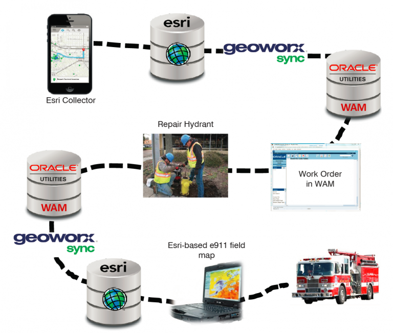
Once their plan was established, the Fire Department crew started using Collector for ArcGIS from Esri to gather and update hydrant condition information in DWSD’s geodatabase, in real time. In order to make the greatest use of this mobile data collection technology, DWSD found that they would also need to synchronize their updated geospatial data with their work and asset management system (Oracle Work and Asset Management). To solve this, they adopted GeoWorx Sync, a commercial off-the-shelf software for GIS and enterprise system integration. GeoWorx Sync was installed and configured within one workday, allowing DWSD to immediately start sharing hydrant data between the two disparate databases.

Now, as the Fire Department collects hydrant condition data using Collector, that data is also pushed to DWSD’s asset management system and if hydrants are found that need repair, a work order is created. Because GeoWorx Sync provides bi-directional synchronization, once the hydrant has been repaired and the work order is closed in the asset management system, the geodatabase is updated with the repaired hydrant data. GeoWorx Sync runs daily to ensure that hydrant data is up-to-date on the Esri-based e911 field map for Detroit’s firefighters.
These new data collection and integration methods have drastically improved hydrant status awareness in the City of Detroit. Having an updated, accurate e911 map helps firefighters make quick, informed decisions in dangerous situations and ultimately protects Detroit’s residents and property.
To learn more about how the City of Detroit is using GeoWorx Sync to help mitigate fire disasters contact info@geo-nexus.com.